Home Page

RadarUSA2 - RainRadar 1.7 - Google Play


The App download link is detected as malware and was removed.
We recommend you try one of the related apps from below.


About RadarUSA2 - RainRadar

Viewer for USA National Weather Service rain radar. Shows you where the rain is at any given time. Simple and easy to use. Replaces RadarUSA which does not work on newer phones. Works best with a touch screen to zoom it...

Viewer for USA National Weather Service rain radar.
Shows you where the rain is at any given time.
Simple and easy to use.
Replaces RadarUSA which does not work on newer phones.
Works best with a touch screen to zoom it and drag it around and with a fast data connection (3G or WiFi).
RadarUSA2 displays the most recent doppler weather radar (rain) image for a selected location. It shows a map of your area with an overlay of the rain radar image.
The app opens straight up into the most recent map for the selected area. (The images are usually updated every 6 to 10 minutes).
The map can be zoomed in and out and can be dragged around the screen.
Two image sizes are available - 124mile radius and 284mile radius.
The UT and local time is shown at the top of the image.
The 284mile option is about half an hour behind the current time owing to android not fully supporting animated gifs.
.
Add it to your home page and it is there at your fingertips to view at a moments notice.

INSTRUCTIONS for USE:
The very first time the app is run, it fires up in the 'States' 'menu'.

Tap on your State and the radar locations in your state will then be displayed.
Tap on the one nearest you and your map will be displayed.
By using the 'menu' button (or icon) you can get back here at any time and change the location.
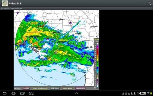
The last location selected will then be the default location - this image will then always display immediately you start the app. (until you change it again).

The menu display also has 'north', 'south', 'east', and 'west' navigation buttons. Tapping one of these will load the image for the next location in the selected direction.

The final button in the 'menu' display is '284mi radius'. Tapping this will double the area covered by the display from 124 miles to 284 miles - for one time only.
This coverage reverts automatically to the standard 124 mile radius the next selection.

If you have a touch screen, you can pinch, expand and drag the image to get a closer look at a location.

The images are quite large and you should really have a wifi connection or a very good signal to get the best loading speed.


Previous Versions

Here you can find the changelog of RadarUSA2 - RainRadar since it was posted on our website on 2013-08-23 00:47:23. The latest version is 1.7 and it was updated on 2024-04-22 09:58:16. See below the changes in each version.

RadarUSA2 - RainRadar version 1.7
Updated At: 2013-03-04
RadarUSA2 - RainRadar version 1.7
Updated At: 2013-03-04
Changes: Several fixes and updates


Related Apps

Here you can find apps that are similar with RadarUSA2 - RainRadar.


Disclaimer

Official Google Play Link


We do not host RadarUSA2 - RainRadar on our servers. We did not scan it for viruses, adware, spyware or other type of malware. This app is hosted by Google and passed their terms and conditions to be listed there. We recommend caution when installing it.

The Google Play link for RadarUSA2 - RainRadar is provided to you by apps112.com without any warranties, representations or guarantees of any kind, so access it at your own risk.

If you have questions regarding this particular app contact the publisher directly. For questions about the functionalities of apps112.com contact us.

BarCode2D-PNG


Click stars to rate this APP!

Users Rating:  
  3.0/5     1
Downloads: 1
Updated At: 2024-04-22 09:58:16
Publisher: oze-apps
Operating System: Android 2.2 And Up
License Type: Free Trial